Leo, here’s an item for future consideration. The ability to schedule imaging based on time to/from the meridian. Prime imaging time often centers on the meridian. So for example define a sequence that would start 2 hours before the meridian and finish 3 hours after the meridian.
I raised this as an enhancement last week so I think LO already has an additional DO IF statement on his list for this but if it needs to go anywhere else then that would be good too.
I for one never image based on altitude because of trees, it’s always meridian centric. Currently I check the meridian transit times, translate them into real imaging times and use as start/end times. +/- hours from the meridian would make it very easy and save having to adjust due to the date each week or so.
Hi Leo, I had thought of finding the altitude of an object say at 2 hours before it reaches the meridian and then setting sequence to start then and run for say 4 hours. That’s do-able. The issues I see is that each object is different, and even for the same object, the altitude 2 hours before the meridian changes from night to night. So having the computer figure all that out makes it a lot easier. You could copy the settings to a new sequence and just plug in a new target and there it is!
Indeed! What would be even more useful would be a way for Voyager to read a horizon profile file from a simple text file (many observation and planetarium software do this, CdC being one) and figure out if above horizon to restrict imaging such object. Voyager already figures out rise, transit and set times for a target and it would be a matter of checking these against horizon file to determine imaging slot.
Good point Roberto, it would help but for the simplest approach (in my opinion) a DO IF within meridian hours would be the easiest to code. A DO IF altitude would be different for each object as Wayne has mentioned so requires more setup time. I agree that an altitude based approach might be better in some circumstances but some of my imaging targets are within 10-15 degrees of the zenith before I can image them. Taking an altitude based approach also assumes the object is available symmetrically about the meridian which is not the case for me. To find out the altitude I need to map my visible sky to a planetarium program then find the point at which the target is visible (east) but then the western altitude is different - I need to calculate how long it’s visible for and set the imaging time accordingly (or guess). A meridian hours based approach could remove all this complexity (for me anyway).
You might want to look at SkyTools 4 - Imaging in the meantime. You can set up a local horizon, tell it what you want to image, and it will draw a curve showing you when that object is above your local horizon plus give you an indication of imaging quality. Lots, lots more, but it is an essential part of my setup for my night’s Voyager run.
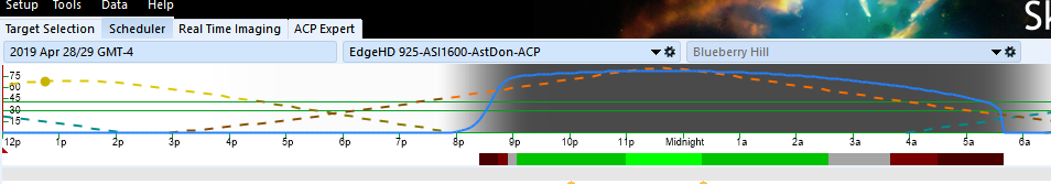
E.g., here’s the night bar for M94 for tonight. The blue line is imaging quality. The horizontal green lines are 30 and 40 degrees altitude. The red dashed line is M94 - it goes from red to grayed out if M94 is behind the local horizon. I just pick the start and end times from this graph, and usually run my filters so R is at least altitude, then G, B and L at highest.
Leo - had to think about it and you’re right! If a target is 2 hours from the meridian at 60 degrees altitude, even if the date changes and the target reaches the same altitude earlier, it’s still 2 hours from the meridian. It still would be convenient to just select a time from meridian and than apply it to any target.
The other thing on altitude I can’t get my head around is that the altitudes repeat on either side of the meridian - once rising and once setting below. So if I want to start when the target reaches 60 degrees pre-meridian and stop when it goes below 70 degrees, not sure how I can do that with altitude statements.
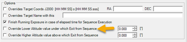
You can do it in the Sequence definition or in the DragScript action that runs the sequence. Here’s the place where you set it in the DragScript block:
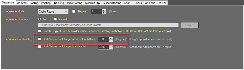
and in the Sequence configuration:
I do have ST4 Imaging but have had trouble getting my head around parts of it, particularly the exposure recommendations e.g. 1200 2-second images to maximize SNR. But I’ll give the target planning another try. Thanks!
The exposure recommendations can be strange. I think especially for CMOS cameras as they behave differently from CCD and I don’t think all ST4’s calculations work well with CMOS yet.
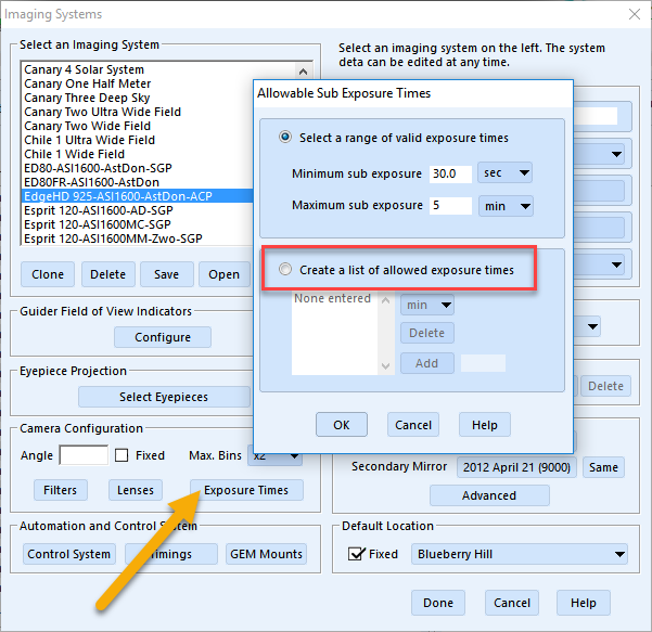
I went into the Setup -> Imaging Systems and put some limits on allowed exposure times and that made the suggestions a lot more useful.
Leo, apologies for diverting into SkyTools 4 help on your forum !
There is also SharpCap Pro (3.1 only) that has built in Sensor analysis. The analysis is saved and can be used to recommend optimum sub exposures based on conditions (it takes various exposures and produces a graph). It’s been designed particularly (although not wholely) with CMOS chips in mind.

 But I’ll give the target planning another try. Thanks!
 !
!